Worth watching out for.
— John Cleare
Scottish Highlands Hillwalking guide
Excerpt:
Sample route guide: Suilven
Contents list | Introduction | Munros | Accommodation | Food & drink | Sample route guide: Suilven
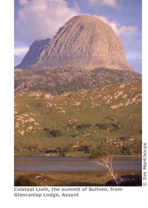
SUILVEN ('Sool-ven', 731m/2400ft)
MAP 43a, p236; MAP 43b, p237
Overview
Suilven is Scotland's sugar-loaf mountain; like a punched fist through a cold floor of rock and water. Many walkers are so beguiled by this inselberg, spared by the giant ice sheets of long ago, that it often comes first on their list of favourite peaks. It is certainly the most individual and most recognizable of Scotland's many mountains and manages to attract all the plaudits despite its very modest height. Reaching the top is easier than it looks but it does involve a long walk in.
Route
Cars can be driven as far as the lay-by just before Glencanisp Lodge, about a mile east of Lochinver. For those without a car it's a 15- to 20-minute walk. Follow the track past the lodge and continue on it through a small field of gorse. A path continues beyond this field and follows the north bank of the river over open ground for about an hour, with the mighty pillar of Suilven's main peak, Caisteal Liath ('Cashjowl Leea'), ahead.
Just before the hut at Suileag the path splits. Follow the right-hand fork for another half an hour. Soon after crossing a bridge a less obvious path deviates from the main riverside path before a second bridge. Follow this very boggy trail up and over the rough ground ahead. The path rises in a series of rolling shelves and passes by small lochans on each side.
Shortly beyond this the sheer side of the mountain is reached. The path continues straight ahead, up the very steep slope. The climb is a tough slog but is not difficult and is soon over. Once on the spine of the mountain the views across the surrounding bedrock of Lewisian gneiss can be fully appreciated. All of the Assynt peaks come into view with spiky Stac Pollaidh to the south across the lochans and knolls, Quinaig and Canisp to the north and, in the east, the only two munros in the area: Ben More Assynt and Conival.
The summit is not far from the saddle. Follow the rising ridge to the west, past a rather unexpected stone wall that straddles the back of the hill, to the flat grassy summit of Caisteal Liath. A short excursion along the ridge to the east top of the mountain is strongly recommended but be warned that the final climb is for competent rock-climbers only. Non-climbers can still venture a little way along the ridge, which is narrow and quite spectacular in places. The return is along the same route or, alternatively via the southern approach path which comes out a few miles south of Lochinver at Inverkirkaig.
Alternative routes
The southern approach to Suilven from Inverkirkaig is about the same length as the route described above.
Scottish Highlands Hillwalking guide
Excerpts:
- Contents list
- Introduction
- Munros
- Accommodation
- Food & drink
- Sample route guide: Suilven
Price: £13.99 buy online now…

Latest tweets