Guides that will send you packing.
— Today
Morocco Overland
Excerpt:
Sample route - High Atlas: Midelt – Agoudal – Dades
Contents List | Introduction | When to go | Where to go | What can I do in... | Sample route - High Atlas: Midelt – Agoudal – Dades
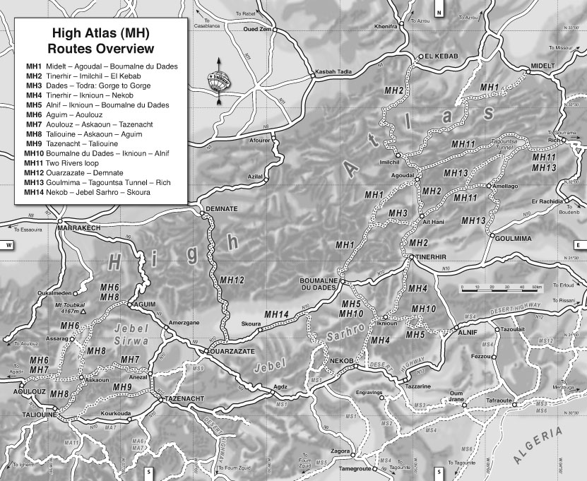
SAMPLE ROUTE – HIGH ATLAS: MIDELT – AGOUDAL – DADES
Outline of the High Atlas region
Stretching from Midelt south-west to Aoulouz, ’MH’ is the biggest
region in this book. It includes the geologically separate Jebel Sirwa
and Jebel Sarhro massifs south of the High Atlas which are neither
the Sahara or the Anti Atlas. Along with the ‘MS’ zone, this is the
most visited area in this part of Morocco where the landscapes and
Berber culture sum up the appeal of the south. Certainly you’d
want to attempt either Trans Atlas RoutesMH1 or -2, as well as a
couple of tracks in the Sirwa and Sarhro massifs.
Visually the High Atlas itself is not so dramatic compared to
the arid south and some villages can have a gloomy, sodden feel.
The lower elevations of the Sirwa and noticeably more arid Sarhro
massifs are more reliable destinations in mid-winter.
MH Routes
MH1 Midelt – Agoudal – Dades 317kM p109
MH2 Tinerhir – Imilchil – El kebab 241kM p114
MH3 dades – Todra ‘Gorge to Gorge’ 45kM p118
MH4 Tinerhir – Iknioun – Nekob 112kM p120
MH5 Alnif – Iknioun – dades 116kM p125
MH6 Aguim – Aoulouz 125kM p127
MH7 Aoulouz – Askaoun – Tazenacht 166kM p128
MH8 Taliouine – Askaoun – Aguim 133kM p133
MH9 Tazenacht – Taliouine 94kM p135
MH10 dades – Iknioun – Alnif 113kM p136
MH11 Two Rivers loop 306kM p138
MH12 Ouarzazate – demnate 158kM p139
MH13 Goulmina – Tagountsa Tunnel 187kM p140
MH14 Nekob – Skoura 137kM p141
TRANS ATlAS: MH1 MIdelt – Agoudal – Dades 317kM
May 2008 ~ Mazda pickup
Description
For those looking to string out the crossing of the High Atlas, this run won’t
leave you disappointed. It gets off to a great start following the popular
Cirque du Jaffar out of Midelt, under the snow-bound slopes of the 3700-
metre Jebel Ayachi. The ’cirque’ refers to the amphitheatre-like valley head
you drop into and climb out of and is just one highlight on this route. You
rejoin the tarmac at KM37 which, barring the latest flood damage, continues
all the way through mountain villages to the Imilchil–Rich road and onwards
south to Agoudal.
Here starts the main crossing of the range, unsealed and likely to remain
so now the parallel crossing to Ait Hani has been completed. Even in good
conditions it’ll be slow progress to the 2906m Tizi-n-Ouano, the highest route
in this book. The descent commences alongside the gorge of the upper Dades
to Msemrir and the resumption of tarmac down the Dades Gorge, bedecked
with all the rich fruits of tour-bus tourism. If you’ve enjoyed the wilds,
Boumalne du Dades is not such a propitious spot to end up. Ideally you’ll
have got here in time to head into the Jebel Sarhro massif directly ahead.
Off road
The descent into the Oued Jaffar can be the roughest section of the route but
piste or asphalt, anywhere prone to flood damage will get gnarly and in win-
ter over the top from Agoudal to Tilmi won’t be a snow-clearance priority.
Mud and snow make things exhausting on a heavy motorcyclewithout knob-
bly tyres and in such conditions it could be an epic for sure.
Setting off in a regular carat any time is bound to be an adventure too and
on a mountain bikeit will be a fair old trek. If you don’t want to camp you’ll
have to plan your riding days quite closely.
Route finding
As is so often the case, getting out of Midelt can be tricky but once on the way
tarmac leads all the way to Agoudal from where there’s only one way over the
top. Olaf no longer lines up with the sealed road in the middle of this route.
Traffic will amount to other off-road recreationists in the Cirque, and
locals, including road crews. Over the Tizi you’re back in the domain of adven-
ture tourists again. The mapis on pp116-17.
Fuel and water
Fuel only at each end and Imilchil for sure, though there may be some in the
bigger villages at a price. There’s plenty of water running in the creeks, in the
village wells, from stores and maybe the heavens too.
Suggested duration
Of all the routes in this book MH1 can get quite a beating from the elements,
so allow for an overnight or keep the wick turned up. In good conditions a
mountain biker could cover this route in 3 or 4 tough days and end up with
quite a sense of achievement.
0km N32° 41.07’ W04° 44.60’
Midelt town centre roundabout with Shell and Total fuel stations. One way of
getting to the start is to head north past a red and white bollard in the road and over
a bridge with red and white posts. In 600m (N32° 41.31’ W04° 44.80’) turn
left onto a minor road. If you’re coming from the north you’ll see a brown sign
indicating ’Circuit Touristique Jaffar’ pointing right.
1.3 (315.7) N32° 40.93’ W04° 44.89’
Turn right below some ruins. The general direction is SW.
6 (311) N32° 38.53’ W04° 45.88’
Tarmac ends. Carry on past junctions left and right. The way ahead is clear.
13 (304) N32° 36.25’ W04° 49.07’ Junction; continue SW. In 4km you’ll find
yourself turning south through the cedars towards the mountains. At KM21 you
may pass between barbed wire fences.
25.5 (291.5) N32° 33.77’ W04° 54.09’
Fork with an arrow on a rock. Curve left, south, up into the pass where the track
becomes rubbly. The other track to the right turns north then west.
26.5 (290.5) N32° 33.20’ W04° 53.68’
Come over the pass (2262m; flat space to camp) and enter the Cirque. Start a loose
descent, in a car inching round a huge fallen boulder on the off-side. Down below
are flat-roofed dwellings.
At KM29 turn sharp right as you cross a oued and begin climbing round a spur.
30 (287) N32° 32.47’ W04° 53.74’
Junction. Left may be rough so descend right to the valley floor and meet the kids
who’ve heard you coming and may have prepared their traps!
30.5 (286.5) N32° 32.35’ W04° 53.81’
Cross a oued prior to climbing back out of the cirque. For us the kids half-heartedly
blocked the way here with stones. There are no real options to go wrong but once
you’re ascending to the NW past fence posts through cedar woods to either side,
you’re on the right track.
34.5 (282.5)
The cirque is behind you now as the ground opens out onto a good earth road.
38 (279)
A nice camp spot as you cross a small oued.
44.5 (272.5) N32° 32.29’ W04° 58.49’
Pass a settlement in the meadows with a view to the northern plains and the snowy
peaks to the south. A rutted, dried-mud section may follow.
48.5 (268.5) N32° 31.77’ W04° 59.49’
About two-and-a-half hours driving from Midelt you get to this key junction where
a sign says: ’Tiz-n Zou 10; Tounfite 30; Imilchil 130’. Turn right here if you’re just
doing the loop back towards Midelt otherwise continue straight ahead on a good
forestry track for a few kilometres.
52 (265)
Ait Ouchchen village, meadows, poppies, wheat. All very scenic – in spring at least.
60 (257) N32° 31.06’ W05° 03.46’
Go straight down towards the villages making up Tizi-n-Zou.
63 (254) N32° 31.04’ W05° 05.07’
Cross what may still be a narrow bridge with railed sides. Or dive through the
river if you’re feeling sporty or are too wide. All around are cypress and cedar
trees dotting the barren, ashen slopes.
73 (244) N32° 29.91’ W05° 10.53’
Junction. If not already on it then join the tarmacand turn left for Imilchil.
91.5 (225.5) N32° 23.49’ W05° 09.97’
A gîtein Tagoudit village.
93 (224)
Turn left at a sign ’Imilchil 85km’ on a road which bypasses Agoudimvillage.
97 (220) N32° 21.56’ W05° 11.05’
Oudadn Aubergeby an apple orchard, a lovely place for a lunch break, overnight
or simply just to get snowed in.
110 (207) N32° 19.46’ W05° 16.09’
Anemzi village.
132 (185) N32° 17.40’ W05° 23.83’
Junction at the edge of Anefgouvillage to the left. ’Imilchil 47’.
136 (181)
Tighiste village. Willows, grass and a National Park Forestry centre.
147 (170) N32° 12.45’ W05° 27.31’
The track tops out at 2649m. On the far side are pastures with horses; it looks a
good spot for camping.
151 (166)
Tilhri or Tabanast village.
163 (154) N32° 09.14’ W05° 34.46’
Reach the R317 road. Left is for Agoudal and Dades. Right is for Imilchil (9km,
fuel) on Route MH2.
174 (143) N32° 05.99’ W05° 30.62’
Turn right and pass through villages.
190 (127) N32° 00.53’ W05° 29.39’
Agoudal centre at 2350m. The road follows MH2 SE over the oued to Todra. You
turn right, join the main route out of town and head for the hills.
197 (120) N31° 58.70’ W05° 32.72’’
Go straight not left at a ’Grotte Akhiam’ sign. Drive in the oued. In 1km pass
buildings on the right with possible diversions. There are signs and blue arrows on
the rocks to show the route. After another 1.5km there’s a cistern
on the left and soon a narrow passage above a gully. In a kilometre or so the
grassy pastures could make nice wild
camps.
204 (113) N31° 57.25’ W05° 36.09’
Short cut directly uphill, otherwise go left.
213 (104) N31° 54.70’ W05° 39.73’
Tizi-n-Ouanohighpoint at 2906m. Some buildings and a bit of rubbish. Good
views to the south over the upper Dades.
219 (98)
Tilmi village lies far below with the deep gorge below left. In about 3km the big
descent begins with occasional steep short cuts and washed-out bends.
229 (88) N31° 50.93’ W05° 44.05’
Junction with a valley to the west. You carry on straight and in 500m cross a oued
back on the valley floor with the orange GiÌ‚te d’eÌtape Ighounta on the far bank.
Crops and cultivation resume with flowery meadows all around in spring.
235 (82) N31° 50.02’ W05° 45.70’
Cross a bridge in Aït Ali Ouikkou.
237 (80)
Izmaguene village.
240 (77) N31° 48.03’ W05° 46.59’
Take the left track and in 500m cross a bridge over a oued. Soon there’s a sign:
‘Tilmi Centre’, a track joins from the left and you pass an old kasbah. All this is
within one kilometre.
247 (70) N31° 47.73’ W05° 46.65’
Sign: right to Asaka restaurant and Aït Mohamed. An Olaf loop rejoins from right
(a split from around KM240). In a kilometre maybe a cafeÌ.
251 (66) N31° 43.11’ W05° 48.17’
Reach the upper turn-off for MH3 just before Msemrir.
255 (62) N31° 41.77’ W05° 49.05’
Msemrir town centre (about three hours driving in good conditions from Agoudal)
with a pharmacy, shops and auberges.
285 (32) N31° 31.74’ W05° 55.49’
From around KM280 the hotels begin and at this point, by a cliff-edge hotel, is the
much-photographed ’Dades Gorge hairpins’viewpoint.
The gorge-side hotels and restos multiply and in about 5km on the left is the
posh Chez Pierrerestaurant and auberge. Here you can have as good a meal as
you’ll eat in Morocco and it won’t have to be a tajine, cous-cous or an omelette.
315 (2) N31° 22.49’ W05° 59.55’
Dades central roundabout on the N10 highway. Turn left for fuel and Tinerhir or
right for Ouarzazate.
317 N31° 22.07’ W05° 58.87’
Shell fuel station on south side of Dades.
Morocco Overland
Excerpts:
- Contents List
- Introduction
- When to go
- Where to go
- What can I do in...
- Sample route - High Atlas: Midelt – Agoudal – Dades
Price: £19.99 buy online now…

Latest tweets